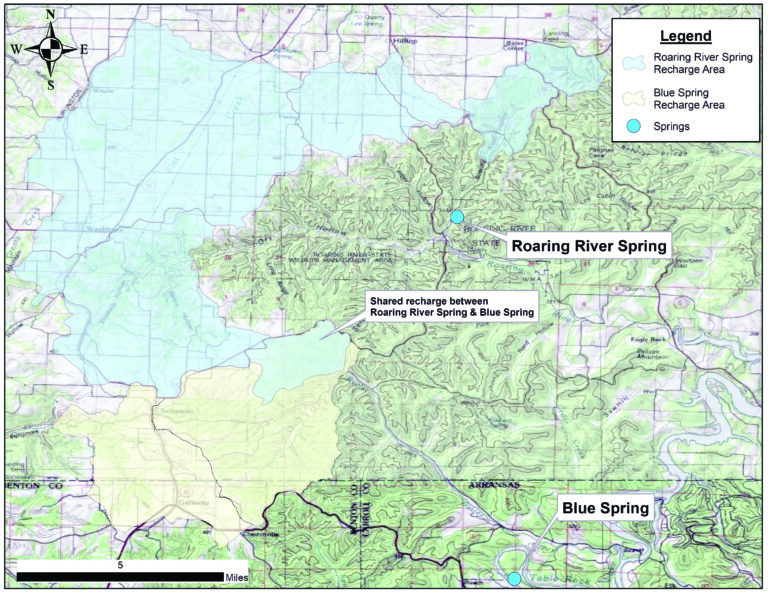
Roaring River recharge basin exceeds 47 square miles
Oddities turn up with dye in Exeter sinkhole, south of Seligman
BY SHEILA HARRIS [email protected]
Dye-tracing tests to determine the extent of Roaring River Spring’s recharge basin are complete, giving a new glimpse into the mystery of where the spring originates.
“The total size of the Roaring River recharge area is 47.34 square miles,” said Hydrologist Ben Miller, a volunteer with the Cave Research Foundation.
That’s over 30,000 acres, an impressive size, but not necessarily unexpected, given that Roaring River Spring is at least 472 feet and has the deepest recorded depth in Missouri.
“[The] northwestern-most corner [of Roaring River’s recharge basin] is in Shoal Creek, upstream from the Highway 76/86 junction [just south of Wheaton],” Miller said.
As the crow flies, Wheaton lies approximately 25 miles northwest of Roaring River Spring.
According to the Missouri Department of Natural Resources’ (DNR) website, the diameter of Roaring River Spring’s recharge basin may not be uncommon. Water entering a sinkhole [or other direct conduit] can travel through subterranean passages for 30 miles or more before surfacing in springs and wells in the Ozarks, they said.
Miller, along with Bob Lerch, fellow Cave Research Foundation volunteer, and Roaring River State Park personnel (including past nature interpreter, Kelly Koch) conducted dye-tracing tests in an ever-widening circumference from Roaring River Spring over a period of several years.
Their efforts, Miller said, were the first major attempt to determine what areas contribute flow to Roaring River Spring.
“Becoming aware of the sheer scope of Roaring River Spring’s recharge area will give people an idea of how easily our water supply is affected by contaminants located miles away from it,” Lerch said.
Lerch cited, for example, the possibility of a chemical tanker overturning on Highway 37, near Washburn.
“Any spilled chemicals [from that area] would almost surely make their way into Roaring River Spring,” he said in a 2021 interview.
In addition to revealing the scope of Roaring River Spring’s recharge basin, the dye-tracing tests revealed quirky mysteries of nature.
For example, dye injected into upper Shoal Creek, beyond the Highway 76/86 junction, showed up in Roaring River, but dye injected into a local phenomenon, the Exeter Sinkhole — which lies closer to Roaring River Spring — flowed in the opposite direction, southwest, toward Thomas Hollow.
An equally fascinating conundrum occurs in Butler Hollow, south of Seligman. There, said Bob Lerch, Roaring River Spring shares a portion of its recharge basin with Blue Spring — near Eureka Springs, Ark. — to the south.
“Some of the water [in Butler Hollow] flows southwest, to Blue Spring; some flows [north] to Roaring River,” Lerch said. “The water that flows southwest actually has to run beneath the White River in order to reach Blue Spring.”
While mysterious, the peculiar flow of groundwater in the Ozarks is a characteristic of its karst underlayment, geology pocked with fissures, conduits, losing streams, rivers, sinkholes, cave systems and springs — all kinds of holes, in other words. Geologists often compare karst geology to Swiss cheese.
According to an article in a Missouri Department of Conservation publication, groundwater in karst environments can travel as much as one mile per day, compared to non-karst environments, in which a travel rate of only a few feet per year is common.
According to the DNR, Missouri has 4,400 springs and 7,500 recorded caves – hence its nickname, “The Cave State.”
The majority of springs and caves are located in the massive Ozark Plateau, commonly called “the Ozarks.” The plateau encompasses some 47,000 square miles, the majority of which are in Missouri.
According to an article in a Missouri Department of Conservation publication, titled “Conserving Missouri’s Caves and Karst,” Barry County contains between 201 and 400 caves. Perhaps best-known is Roaring River Cave, from which Roaring River Spring emanates.
Because of its submerged status, limited exploration has occurred in Roaring River Cave. The spring’s recorded depth was established by the KISS Rebreathers USA dive team in November 2021.
“There’s more depth below [472 feet],” KISS CEO and team leader, Mike Young, said after his and team member Randall Purdy’s record-setting dive.
Miller and fellow Cave Research Foundation volunteers had been studying the extent of Roaring River Spring’s recharge basin before the KISS team’s depth exploration.
“Understanding the area which drains to Roaring River Spring can help efforts to protect the spring and preserve the area for future generations,” Miller said.”
Miller said he and other volunteers are in the process of writing up the results of their research for an upcoming issue of Missouri Speleology.