
Cassville again considering NFIP re-entry
New floodplain maps being finalized, basin plan revisited
BY KYLE TROUTMAN [email protected]
The city of Cassville is again revisiting re-joining the National Flood Insurance Program (NFIP), as new floodplain maps are being finalized by FEMA.
Richard Asbill, Cassville city administrator, said the last time Cassville considered joining the program — which would allow property owners to buy flood insurance and open the city up to federal grant money, while simultaneously creating a new set of rules for properties damaged by any floods in the future — in 2020, but talks fell through.
“It was going well with FEMA, and they were receptive of Cassville coming back, so the city evaluated the pros and cons, and the next step of the discussion was a public hearing,” Asbill said. “Those were canceled at the start of the pandemic, and the city needed FEMA to be here and meet in-person to answer questions. The council and specific property owners had questions and concerns, and because FEMA canceled the in-person meetings, the council chose to take no action and time on that offer ran out.”
Four years later, with new floodplain maps in a 90-day appeal window, Cassville is again approaching the topic, a longstanding and at times contentious issue.
Cassville’s NFIP history dates back to the 1970s, when the city was suspended in 1977 for failing to adopt adequate floodplain regulations. City officials have said they left voluntarily in 1978, as the majority of the city would have been in the floodplain, greatly limiting any new construction.
After a period of suspension, a community may be reinstated if it meets certain conditions.
According to a 2022 Cassville Democrat interview with Todd Tucker, AICP, Natural Hazards Program specialist in the mitigation division of FEMA Region VII, to regain eligibility for the NFIP, a community must adopt adequate floodplain management regulations and provide evidence of actions taken to remedy non-conforming floodplain development (i.e., development that aggravates flood hazards or is not adequately protected from flood hazards) which occurred during the period of suspension. The remedial actions necessary for reinstatement are determined on a case-bycase basis and may include community actions such as removing floodway obstructions, conducting a study to map the change in flood hazards, surveying the lowest floor of existing buildings, notifying property owners of their flood risk or retrofitting structures to provide adequate protection against flooding.
Cassville considered rejoining the NFIP in 2015 after two floods over two days that impacted 30 businesses and 20 homes, causing more than $900,000 in damages. At the time, rejoining would require the city to revert to the 1970s construction requirements, which officials called a non-starter for its businesses due to cost.
Any structure built after 1977 would require the lowest floor, including the basement, to meet the 100-year flood elevation level, and any future structures would likewise have to meet the 100-year flood elevation level.
In January 2021, Steve Walensky, former Cassville city administrator, said the city hoped to get some allowances from state and national agencies to bypass that elevation requirement. A possible re-entry was prompted by participation in the Section 205 program with the Army Corps of Engineers, working with the city on feasibility study to identify mitigation measures for implementation that would reduce the flood hazard.
The Section 205 program is a two-part process — a feasibility study and a project. The Corps pays for up to $100,000 in cost for the feasibility study, then the project is a 65 percent federal, 35 percent local split.
Walensky was recommended by the Corps to apply, and said he was clear that the city was not part of the NFIP, nor did it plan to be at the time.
After the study was done and the city was waiting to hear if it would move on to the second part of the process, it was determined the city would have to be in the NFIP to do so.
Because of that requirement, Cassville initiated conversations with FEMA to get back into the NFIP, and was making headway. The city and FEMA began planning a meeting in the June 2021 to discuss the possibility of rejoining, but that meeting was canceled due to an increase in COVID-positive cases locally. After that cancelation, the council took no action.
“Now, we are in the review process again,” Asbill said. “The Real Time Technical Assistance (RTTA) mapping has been ongoing for at least a year., After the new floodplain maps are done, the window is renewed. We are in the 90-day appeal window right now for the maps, and next, the council will review if we wish to re-enter the NFIP.”
The RTTA is coordinated by the State Emergency Management Agency, and the study’s goal is provide assistance to communities with high flood damage vulnerability, such as Cassville. Along with defining flood risks, the RTTA helps determine the most effective flood reduction alternatives.
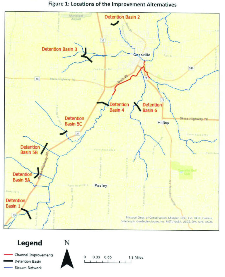
A topic in that vein receiving attention this time around is the proposal of constructing eight detention basins in or near the city, including four along Highway 37 southwest of Cassville, two directly south of Cassville and two north of Cassville.
With 312 buildings in Cassville’s floodplain, each basin removes a certain number. The most impactful would be to build the two in the north, which would lower the number of impacted buildings to 246, a 21% reduction.
Funding to pursue such projects could come with rejoining the NFIP. However, still remaining are the potential impacts after a flood event, namely, that structures considered a total loss would have to be rebuilt to mitigate future flooding, presenting a feasibility challenge.
The city of Cassville has put $80,000 to $100,000 into floodway improvements since the 2016 and 2017 floods, and more recent work has occurred between Main and Townsend Streets, as well as on Sale Barn Road.
“Jerry Watley did a lot of work between Main and Townsend to increase flow based on RTTA guidance,” Asbill said. “If we can keep a clean flow, there’s less impact. Digging deeper doesn’t help us because Cassville is so level in that area. Holes dug out there are intended to catch gravel. Like, the basin by the Barry County Museum, it’s catching gravel that would be over by The Rib.”
Asbill said to further tackle flooding issues, grant funding that becomes available as an NFIP member is a possibility.
“The benefit is we’d be eligible for federal funding to assist in managing flood risks,” he said. “That money can be for anything from gravel removal to bridges [or basins]. The 7th Street bridge is a priority with or without federal funds, but NFIP entry will allow us to apply for grants to lower the costs.
“We are engaging in a conversation about the NFIP, not to say do it or don’t, but to evaluate pros and cons so the council could consider any ordinance. A public hearing will also be required to allow property owners to give their input.”